Reunion and Seychelles partner in weather radar project to improve forecasting
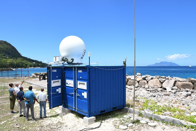
A temporary weather radar has been installed in Bel Ombre, a northern district of the main island of Mahe with the aim of improving forecasting skills and early warning systems during bad weather events in Seychelles.
The installation of the radar is part of the Study of Precipitating Systems in the Indian Ocean by Radar and Satellites (ESPOIRS) to better understand certain weather phenomena of Seychelles' climate and that of the region. ESPOIRS is an INTERREG V project, financed by the European FEDER funds, the Reunion regional government and the French state.
It is also part of a global scientific strategy initiated by the Laboratory for Atmosphere and Cyclone (LACy), the University of Reunion - a French overseas department- and their regional and national partners. The Seychelles Meteorological Authority (SMA) is collaborating on behalf of the 115-island archipelago in the project.
The director of LACy, Joel Van Baelen, said on Monday that "the objective of this project is to gain experience and learn about the big heavy precipitation and convective systems that you have here in the Seychelles Islands."
He explained that the research project looks at the interaction of the rainfall with the orography – which concerns the formation of mountains – and how it impacts the islands.
"There are two parts to the research - scientific and operational. This is why we are having this collaboration with the Seychelles Meteorological Authority. They have the expertise when it comes to precipitation and we bring the radar. We are working together so that we can have a better view and understanding of the systems and the future, all within the framework of global change," said Van Baelen.
Van Baelen added that due to rising sea temperatures brought about by climate change, the Inter-Tropical Convective Zone (ITCZ), where there are higher temperatures over the oceans, will increase.
 |
| For the first time, SMA will use a weather radar considered one of the most important instruments in meteorological and climate science. (Seychelles Nation) Photo License: CC-BY |
"This means that we will have a larger area for cyclone developments. Maybe we will not have more cyclones in the future, but according to the trends we are going to get stronger cyclones. In the tropics, where Seychelles is located, more intense convective precipitations will develop with more accumulative rain. When that rain just hits an island, there will be more rainfall accumulation and the event of flooding or flash floods," said Van Baelen.
The temporary radar, which became operational in late October, has a range of 100 kilometres allowing for predictions of up to 5 hours.
This is the first time that the SMA is able to use a weather radar, which is considered one of the most important instruments in meteorological and climate science. Seychelles is currently using satellite images for its weather forecasting.
Through the regional project, the SMA is also being provided with the opportunity to understand how such a highly sophisticated system is operated and maintained in preparation for a bigger radar next year under a climate change project - HydroMet.
The chief executive of the SMA, Vincent Amelie, said that a permanent weather radar on the island will allow for more precise predictions.
"The limitation of satellite images is that we see the system approaching but we do not know the intensity at which it will hit the country. With a radar, this is exactly what we will know. We will know the approximate density of the rain and the amount of water that it will bring. This will bring more impact-based forecasting. That we will not only be able to tell that the rain is coming but we will also be able to tell the intensity and the impact that it will have on the country and the population," said Amelie.
Amelie also shared that over the past years, a change in Seychelles' rainfall pattern has been observed.
"Previously in Seychelles, during our rainy season, you would see the ITCZ coming well organised forming over Mahe, providing the island with continuous rainfall, at times non-stop. This was good when it came to water conservation. The earth absorbed enough water and we got overflows, which fed into, or created rivers that end up in the dams," said Amelie.
He added that "what we are seeing in the past few years is that it rains in an inconsistent manner for shorter periods. This creates a lot of flooding. We also struggle to collect this water in dams. It is important to understand what is happening as this will provide policymakers to put in place the necessary systems so that we can collect water."
Work is also being undertaken by the authority to improve its warning system, with the aim of bringing the information closer to the public as fast as possible.


